| Manual Ref* | NFbrMW001 Show 2 images | 334 | ||||||||||||||||||||||
| Title* |
Marriott's Way (eight inscribed blocks) |
|||||||||||||||||||||||
| County | Norfolk | District Council | Broadland and Norwich | |||||||||||||||||||||
| Civil Parish or equivalent | NA | Town/Village* | Marriott's Way | |||||||||||||||||||||
| Road | Sustrans National Cycle Route 1 | |||||||||||||||||||||||
| Precise Location | The trail proceeds west from Reepham heading towards Themelthorpe (and departing from the official Sustrans route), then turns south-east towards Norwich in close relationship to the River Wensum and roughly parallel to the A1067 | |||||||||||||||||||||||
| OS Grid Ref | TG099235 to TG196099 | Postcode | NR10 to NR3 | |||||||||||||||||||||
| Previous location(s) | ||||||||||||||||||||||||
| Setting | The Marriott's Way Rural Trail - a peaceful and secluded recreational trail occupying the former railway line between Aylsham and Norwich | Access | Public | |||||||||||||||||||||
|
||||||||||||||||||||||||
|
Commissioned by |
The work was jointly funded around 2000 by Norfolk CC, Norwich CC and Sustrans with a substantial sum of money from a Landfill Tax initiative. | |||||||||||||||||||||||
|
Design & Constrn period |
||||||||||||||||||||||||
|
Date of installing |
2000 |
Exact date of unveiling |
||||||||||||||||||||||
|
Category |
|
|||||||||||||||||||||||
|
Object Type |
|
|||||||||||||||||||||||
|
Subject Type |
|
|||||||||||||||||||||||
|
Subject Sub Type |
|
|||||||||||||||||||||||
|
||||||||||||||||||||||||
|
Work is |
|
|||||||||||||||||||||||
|
Owner/Custodian |
Broadland and Norwich District Councils | |||||||||||||||||||||||
|
Listing status |
|
|||||||||||||||||||||||
|
Surface Condition |
|
|||||||||||||||||||||||
|
Structural Condition |
|
|||||||||||||||||||||||
|
Vandalism |
|
|||||||||||||||||||||||
|
Overall condition |
|
|||||||||||||||||||||||
|
Risk |
|
|||||||||||||||||||||||
| Signatures/Marks | ||||||||||||||||||||||||
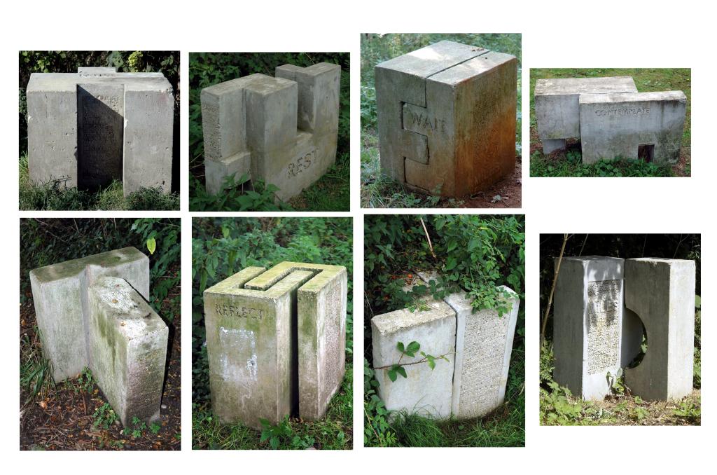
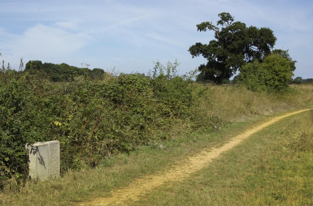
| Inscriptions | Pause - figure pausing in a landscape 21/2 miles from the city centre to look out across the water/ Rest - figure resting in a landscape gazing out from an embankment across open fields which used to be heathland 31/2 miles from Drayton but quiet enough with luck to see roe deer/ Wait - figure in a landscape with hidden river waiting for dusk to glimpse the black wings of bat (Pipistrelle daubentons) or the ripple of an otter only 9 miles from Norwich/Contemplate - figure in a landscape 73/4 miles from Reepham with disused railway and gravel pits contemplating the history of industry their back turned on old concrete factory which once made beams for motorway bridges but now crushes cars/Wonder - figure in a landscape wondering what lies ahead not far from Whitwell common where on 8th April 1844 one William Frost murdered his young daughters the area now a site fs special scientific interest/Reflect - figure in a landscape with bee orchid and clinker at Whitwell station part of the regional network run by the midland and great northern or the muddle and go nowhere which once carried an average of 140 passenger and 80 freight trains a day/Follow - figure in a peaceful rural landscape that feels miles away from anywhere although only 15 miles from norwich trying to imagine locomotives instead of oak trees as their eyes follow the line of the Themelthorpe loop and briefly see cumulus as clouds of steam/Listen - figure in a landscape 2¾ Miles from Themelthorpe looking back at Reepham station and listening for the last passenger train which left on 28th February 1959 | |||||||||||||||||||||||
|
Description (physical) |
Eight concrete block arrangements, each cast in two parts with sand-blasted inscriptions, unevenly spaced along the Marriott's Way Rural Trail between Reepham and Norwich. Each double block has a single word title in shadow lettering and a rectangular panel of poetic text in upper case. The blocks relate to other installations, including 17 inscribed benches and three printed works on paper | |||||||||||||||||||||||
|
Description (iconographical) |
Marriott’s Way is a twenty-one mile foot/cycle path from Hellesdon Bridge in Norwich, through Lenwade, Whitwell and Reedham to Aylsham. Originally it consisted of two lengths of railway, from Themelthorpe to Aylsham, and from Themelthorpe to Norwich. These were joined by the so-called 'Themelthorpe Curve' in 1960. The Themelthorpe-Norwich length was built in 1882, as part of a line running to Melton Constable, by the Lynn and Fakenham Railway Company, which was taken over by the M&GN in 1893. The lines were never very profitable, as there were too few people living in the service area and not enough freight movement opportunities. Concrete product movements from Lenwade were important, so that when the local rail network was rationalised in 1959, the section from Lenwade via Themelthorpe to Norwich was kept open by construction of the Themelthorpe Curve. Once concrete production ceased, there was no reason to keep the line open and it was closed in 1985. The route is named after William Marriott who was chief engineer and manager of the M&GN system for 41 years. According to Les Bicknell the work was defiantly not sculpture. The intention was that the/an audience discovered the work, told other people about it (was it even art) and experienced it as a part of their walk/cycle/ride. Les Bicknell saw his role in the larger development of Marriott’s Way as equally trying to halt development and the adding of ‘stuff’, recognising what was there (nature, industrial material) as much as making new things/work for people to view. The blocks act as waymarkers, and also articulate 'a sense of place' by describing the experience of wandering (by foot or by bicycle) along the Rural Trail. The inscriptions include both historical references and poetic evocations of wildlife and nature. The titles invite walkers and cyclists to pay attention to the natural surroundings - to pause, contemplate and wonder | |||||||||||||||||||||||
|
Photographs |
Date taken:
13/9/2006
Date logged: 3/10/2006 |
Photographed by: |
||||||||||||||||||||||
|
On Site Inspection |
Date: 13/9/2006 |
Inspected by: |
||||||||||||||||||||||
|
Sources and References |
www.publicartonline.org.uk/case/oxbridge/biog_bicknell.php accessed 19-Apr-07 / private communication with Keith Rackham (Perfitt Stonemasons) 9-Mar-07 / Marriott's Way information leaflet (2003) http//www.flickr.com/photos/31375871 (inputted3 Oct 2006) | |||||||||||||||||||||||
|
Database |
Date entered: 19/4/2007 |
Data inputter: |
||||||||||||||||||||||